By LCN Business Desk
Guyana had not surveyed its own minerals from the air, nationally, since 1968. It has now, and on 10 November an Australian explorer told the Australian market that it would fly its own aircraft over its own ground in Region Seven, under the government's programme, and keep what the aircraft found. The state's copy of that survey will be confidential.
The ground being mapped is of declared interest beyond Guyana. United States Deputy Secretary of State Christopher Landau visited Guyana and Trinidad and Tobago in August to discuss energy and critical minerals, days after the Department of War put US$85.5 million of equity into Strategic Bauxite USA, alongside US$64.5 million of private co-investment, to acquire and expand the First Bauxite mine in Guyana and build calcination capacity there. What the state collects when a gold discovery becomes a mine is already set: large-scale gold pays an 8 per cent royalty above US$1,000 an ounce under the published regime, against 2 per cent on Stabroek oil.
What are the three routes to Guyana's geophysics?
A free download, a priced sale through GGMC Geoservices, and participation in the programme as an industry partner.
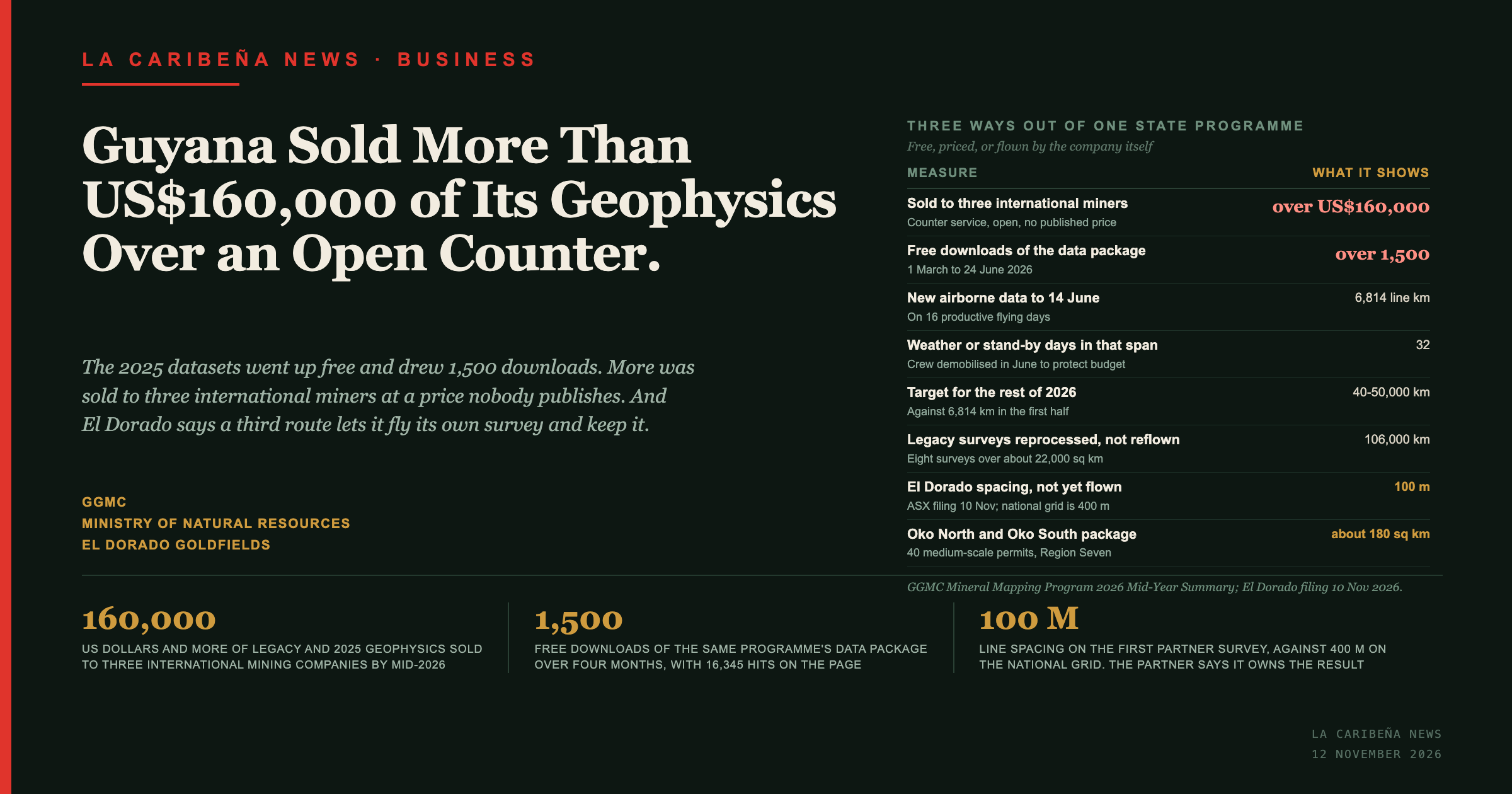
Guyana calls the programme the Guyana Mineral Advancement and Prospecting Strategy, GMAPS. Its 2025 datasets went up on the GGMC website, and between 1 March and 24 June the mineral mapping page took 16,345 hits and 2,250 entry-page visits, with over 1,500 downloads of the free package. Monthly use climbed from more than 300 hits in March to more than 1,400 in June, on the Commission's own mid-year figures for January to June.
In the same half year the Commission "completed the first commercial sales of airborne geophysical data, selling over $160,000 USD of (over 33,000,000 GYD) of legacy and 2025 geophysics data through the GGMC Geoservices process to three international mining companies". Further quotes are in process. The three buyers are not named. The Commission does publish its licence machinery: it found no material deviations from the legal framework governing mineral and petroleum licence awards in 2023 and 2024, across small, medium and large scales, and set out the six documented processes behind that finding.
Nothing in the arrangement is exclusive. Geoservices is a standing counter service with its own published procedure: a customer work request form goes to the Administrative Officer for a manager's approval, an assigned geologist gathers or processes the data and prepares an invoice, payment is made at the Commission's accounts cashier, a senior geologist reviews what was asked for, and the customer collects against the stamped invoice, bringing a drive for anything digital. Eligibility runs "to small and medium scale miners and also Large Scale PL owners / company", so the same holdings are open to Guyanese operators, and quotes still in process describe a running service rather than a closed deal.
What the procedure does not carry is a price. Cost appears once, as "a reasonable cost", with the total set by invoice after the request is approved. No schedule is published, so a prospective buyer cannot know in advance what a dataset costs, and nothing on the public record shows whether the three international buyers paid at the same rate as each other or as a Guyanese miner would.
The third route appears in the same report as a prospect rather than a transaction. Two private companies, named in the document as Fortuna Mining and Mako Mining, "have indicated an interest in participating in the mapping program through the Ministry", with details still to be finalised, and the report notes this may increase the programme's 2026 coverage beyond the planned work plan. Neither had announced a survey by mid-year.
Who is flying the first partner survey?
El Dorado Goldfields, over 180 square kilometres at Oko in Region Seven.
The company told the Australian Securities Exchange on 10 November that it had commissioned an airborne magnetic survey across its Oko North and Oko South gold projects in the Cuyuni mining district, a package of 40 medium-scale mining permits. The survey runs to about 2,440 line kilometres, roughly 1,509 of them over Oko South and 930 over Oko North, with flight planning complete and acquisition targeted for the current quarter. The magnetics run alongside a soil geochemistry programme of about 5,000 samples, and the company's stated purpose is to integrate the two sets to prioritise targets for trenching and a maiden drill programme.
The survey sits inside the government's industry partners arrangement, coordinated through GMAPS and managed by Global Venture Consulting on behalf of the Ministry and the Commission, with the contractor handling programme management, government coordination and contract administration. El Dorado retains ownership of the data, and the Ministry and the Commission hold a confidential archival copy. Discovery Alert and Kalkine both carry that arrangement from the 10 November filing, as does Kaieteur News, which reported it in Guyana the following day and quotes executive chairman Nicholas Katris saying that flying under the government's programme "gives us a high-quality dataset quickly and cost-effectively". The company's claim of time and cost advantages over a standalone survey is made without figures.
The firm reaching Oko under this route is newly renamed. It was Liberty Metals until shareholders approved a change of name on 14 October, and it has traded as El Dorado Goldfields under the code EDO since the open on 23 October, a date confirmed on the exchange's own code changes table. It acquired a 90 per cent interest in the Oko projects in August.
What a company secures in writing from the Guyanese state has mattered before. Five mineral agreements reviewed by this newspaper carry the same clause word for word: if a new law increases what a company must pay or do, the state restores it to the position it held. Data ownership in a partner survey is a contractual term of a different kind, and the Ministry and the Commission have published no terms for the industry partners arrangement, which appears in the mid-year summary only as a sentence recording interest.
Is this new flying, or part of the national survey?
New flying, and it has not happened yet.
The company's filing has flight planning complete and acquisition targeted for the current quarter, and Rio Times reports the flight date as unconfirmed. The survey is specified at 100-metre line spacing over the two Oko blocks, which is not a resolution the national grid produces, so it cannot be a slice of coverage the state was flying anyway. The state has its own language for what partner participation does. Arrangements under discussion at mid-year "may lead to an increase in the coverage of the program for 2026 beyond the planned work plan".
What is not established is who puts the aircraft in the air. No source found says whether the partner survey uses the same aircraft, crew or survey contractor as the national programme, which had an aircraft stationed in Guyana through the mid-year pause and is managed by the same firm. Rio Times notes that neither the Commission's page nor the company's own pages say whether the El Dorado survey forms part of the government programme at all; the statement that it does comes from the 10 November filing, and three outlets carry it from there.
How does a partner survey compare with the national grid?
The two are flown to different specifications, and the difference is in the line spacing.
| National GGMC 2025 survey | El Dorado partner survey | |
|---|---|---|
| Traverse line spacing | 400 m | 100 m |
| Tie line spacing | 2,400 m | not stated |
| Line kilometres | 37,266 | about 2,440 |
| Area | 12,264 km² | about 180 km² |
| Data types | magnetic, radiometric, gravity | magnetic |
| Who owns it | Government, released free and sold | El Dorado, with a confidential government copy |
Sources: GGMC survey page for the national grid; the company's 10 November filing as reported above.
The national survey's extent is given two ways on one page. The Commission's narrative describes a survey "covering 14000 square kilometers"; the survey table beneath it records 12,264 square kilometres and 37,266 line kilometres for the GGMC 2025 acquisition. The national survey is a reconnaissance instrument and the partner survey is a targeting one, so the specifications are not competing attempts at the same job. What follows from the table is that the most detailed magnetic coverage of this particular ground will not sit in the national dataset that the programme exists to build. The arrangement is also the cheaper way for a company to obtain it, on the company's own account, and the state receives flying it did not fund.
What does the programme's own delivery record show?
Weather, and a budget decision taken because of it.
New magnetic, radiometric and gravity data ran to 6,814 line kilometres by 14 June, from 16 productive flying days against 32 weather or stand-by days, which the Commission calls "an exceptionally prolonged period of unsuitable flying conditions". The flight crew was temporarily demobilised in June "to protect the program budget" while the aircraft stayed in Guyana, and the team used the pause for permitting, regulatory coordination and planning. Acquisition was expected to resume in August, with 40,000 to 50,000 line kilometres targeted for the remainder of the year.
Set against the first half's 6,814, that second-half target is the figure to watch, and it is the programme's own. Where re-flying was avoidable the contractor did avoid it: eight historical surveys totalling approximately 106,000 line kilometres over approximately 22,000 square kilometres were reprocessed into what the report calls modern, exploration-ready datasets, "without the cost of re-flying previously surveyed areas", and the report notes those products are potentially marketable.
The survey plan itself was drawn with land status in mind. It was developed with the Ministry and the Commission and prioritises the most prospective mineral belts "while minimizing flights over Amerindian titled lands, protected areas and locations where future mineral development may face significant land-use constraints", with priority areas including greenstone belts extending south toward Eagle Mountain and Mahdia, and the Marudi Mountain region. The plan records a planning choice rather than a legal position, and consent on titled land is governed elsewhere: four licences awarded over Amerindian titled land went to the Commission without the free, prior and informed consent the Amerindian Act requires. Marudi Mountain sits in Region Nine, where on 6 November villages refused an onshore drilling proposal and the consent provision in the Amerindian Act was found to reach minerals but not petroleum. The mapping programme also reports completed interpretation and technical reporting for the Takatu Mountains, drawing on more than 500 samples from its 2025 field campaign. The Takatu Mountains programme is mineral work, and the Takatu petroleum block of the same name in the same region is a separate concession under a separate statute; the shared name is the Takutu basin's, not one project's.
What has the programme cost?
Three figures are in circulation, for different scopes and in different currencies, and neither the Commission's mid-year summary nor its mineral mapping page carries a programme total.
- G$400 million was allocated in Budget 2024, the Guyana Times reported, for the contract awarded in mid-2024 to the United States firm Global Venture Consulting. - US$4 million is the figure for the aerial remote sensing component, attributed to the Commission's Commissioner, Newell Dennison, by Demerara Waves on 1 October 2025. - Some $4 billion is the figure Kaieteur News gave for the government's investment in the project on 11 November 2026, without stating a currency.
The three figures are not the same quantity, and the published record does not reconcile them. No cost or budget figure appears anywhere in the programme's own report to the public, which dates the GMAPS contract to April. This newspaper set out the programme's shape in September, when the open question was whether the survey would establish that Guyana holds lithium.
What else is being built with it?
A data room, a permit system and a digitisation pipeline, all dated to the second half of 2026.
A National Mineral Data Room at the Ministry is specified with three public workstations, 20 terabytes of expandable enterprise storage, redundant network infrastructure, cybersecurity controls and access monitoring, and is intended as a secure national backup and a supervised public access point. Installation was targeted for August and September. A Land Information Management System allowing online mining permit applications for large and medium-scale miners had moved to external testing with Commission personnel and representatives of the Guyana Gold and Diamond Miners Association, and was "prepared to go live in August 2026".
The archive itself runs to 23,397 historical geological files, approximately 610 gigabytes, on an inventory completed in the same period. Bauxite was selected as the first digitisation pilot, the report says, because of significant interest in that sector, and of 970 files reviewed, 679 unique drill-log documents running to approximately 38,600 pages were marked for conversion, with around 100 into the process by the reporting date and outputs intended for three-dimensional geological modelling.
What the state earns from that interest is a separate matter: Guyana charges a single royalty rate of 1.5 per cent on every grade of bauxite, and its schedule does not separate the refractory grade, which does not go to aluminium smelters.
Five Guyanese miners were identified with the miners' association to receive technical data packages and exploration programmes, with the exploration plans due in the autumn of 2026 and the technical reports by the year's end. Those five are the programme's direct support to Guyanese operators.
The entities
- Guyana Geology and Mines Commission (GGMC) is the state body regulating mining and holding Guyana's geological data, and the publisher of the mid-year summary this report draws on.
- Ministry of Natural Resources is the parent ministry, and with the Commission the counterparty to the mapping contract and the holder of the archival copy of partner surveys.
- GMAPS, the Guyana Mineral Advancement and Prospecting Strategy, is the national mineral mapping programme, its contract signed in April 2026.
- Global Venture Consulting is the United States firm managing the programme for the Ministry and the Commission, handling programme management, government coordination and contract administration.
- GGMC Geoservices is the process through which the Commission sold legacy and 2025 geophysics data commercially.
- El Dorado Goldfields is an Australian-listed explorer, ASX code EDO, formerly Liberty Metals, holding 90 per cent of the Oko North and Oko South gold projects.
- Nicholas Katris is El Dorado Goldfields' executive chairman.
- Fortuna Mining and Mako Mining are the two companies the mid-year summary names as having indicated interest in participating in the programme.
- Guyana Gold and Diamond Miners Association (GGDMA) is the industry body that helped select five Guyanese miners for technical support and took part in testing the permit system.
- Oko North and Oko South are gold projects in the Cuyuni mining district, Region Seven, together 40 medium-scale permits over about 180 square kilometres.
- National Mineral Data Room is the planned facility at the Ministry for secure backup and supervised public access to programme data.
- Land Information Management System (LIMS) is the system for online mining permit applications by large and medium-scale miners.
Figures
- Over US$160,000, over G$33,000,000: value of legacy and 2025 geophysics sold to three international mining companies by mid-2026. Both figures are floors in the source, not exact totals. Source: GGMC mid-year summary. - Over 1,500: free downloads of the data package, 1 March to 24 June 2026. Source: as above. - 6,814 line km: new airborne data acquired to 14 June 2026, on 16 productive flying days. Source: as above. - 40,000 to 50,000 line km: target for the remainder of 2026. Source: as above. - 106,000 line km over 22,000 km²: eight historical surveys reprocessed rather than re-flown. Source: as above. - 23,397 files, 610 GB: historical geological holdings inventoried. Source: as above. - About 2,440 line km at 100 m spacing: the El Dorado partner survey at Oko. Source: the company's 10 November filing, as reported by Discovery Alert. - 40 permits, about 180 km²: the Oko North and Oko South package. Source: as above. - 1968: the last national-scale aerial mineral mapping of Guyana before this programme. Source: US International Trade Administration.
Frequently Asked Questions
What is GMAPS?
The Guyana Mineral Advancement and Prospecting Strategy, the name the Guyana Geology and Mines Commission and the Ministry of Natural Resources give to the national mineral mapping programme. Its contract was signed in April 2026 and it is managed by Global Venture Consulting on the government's behalf.
Can anyone download Guyana's airborne geophysics free?
Yes, for the 2025 datasets, which went up on the GGMC website and drew over 1,500 downloads of the free package between 1 March and 24 June 2026. Separate commercial sales of legacy and 2025 data ran through the GGMC Geoservices process over the same period, so not all of the holdings sit on the free tier.
Who owns the data from a survey flown under the industry partners route?
On the reporting of El Dorado Goldfields' 10 November filing, the company retains ownership of the survey data it commissions, and the Ministry of Natural Resources and the Commission hold a confidential archival copy.
Which companies have bought Guyana's geophysics?
Three international mining companies bought legacy and 2025 data by mid-2026, according to the Commission's mid-year report, which does not name them. Fortuna Mining and Mako Mining were named in the same report as having indicated interest in participating in the programme, which is a different arrangement from buying data.
What is El Dorado Goldfields?
An Australian-listed explorer, previously Liberty Metals, which has traded under the code EDO since 23 October 2026 following a shareholder vote on 14 October. It holds a 90 per cent interest in the Oko North and Oko South gold projects in Region Seven, acquired in August 2026.